| Earth from Space is a free eBook describing our planet from a satellite's perspective. Fore more information, please read the About pages. |
|
Home  South America Argentina Cerro Aconcagua South America Argentina Cerro Aconcagua |
|
| See also: Cerro Antuco and Laguna de Laja | |


|
  |
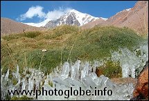
Cerro AconcaguaPosition of center of photo (Lat/Long): [-32.73854/-70.06047] |
|
  As the tallest mountain in South America, Cerro Aconcagua (or Aconcagua Mountain) As the tallest mountain in South America, Cerro Aconcagua (or Aconcagua Mountain)  is one of the Seven Summits: the highest peaks on each of the seven continents. Its name is believed by many to come from an ancient native name of "Ackon Cahuak" meaning "Stone Sentry." It is 6,962 meters (22,840 feet) to the top of the North Peak, making it the second highest of the Seven Summits. Aconcagua is located in the midst of the Central Andes in Argentina, one range east of the ridgeline that defines the border with Chile. is one of the Seven Summits: the highest peaks on each of the seven continents. Its name is believed by many to come from an ancient native name of "Ackon Cahuak" meaning "Stone Sentry." It is 6,962 meters (22,840 feet) to the top of the North Peak, making it the second highest of the Seven Summits. Aconcagua is located in the midst of the Central Andes in Argentina, one range east of the ridgeline that defines the border with Chile.
The first recorded attempt to climb the mountains summit occurred in 1833 by the German explorer, Paul Gussfeldt. Despite the limitations of mountaineering equipment in that era, very limited cartographic information, and with no knowledge of the conditions around the summit, he nevertheless managed to climb to within 500 meters of the summit. (The first surveying of the mountain was done two years later by Charles Darwin during the voyages of the Beagle.) In January of 1897, a Swiss guide, Mathias Zurbriggen, successfully reached the peak via a route pioneered the previous year in an English expedition in which he had been a member. It entered a valley near the mountain at Laguna de Horcones, ascending through the valley to Plaza de Mulas, and then back along the northwest ridge of the mountain. This route has since become known as the "normal route" and is the most popular and least technically challenging approach to the peak. A number of expeditions have since explored other routes. Many cross features named by the nations that first led these expeditions, such as the Polish Glacier, Plaza Argentina, and Plaza Francia.
|
| Source of material: NASA |
Further information: WikiPedia article on Cerro Aconcagua
Last Update: 2011-03-30