| Earth from Space is a free eBook describing our planet from a satellite's perspective. Fore more information, please read the About pages. |

|

Home  Africa Africa  Mauritania Mauritania  Banc d'Arguin National Park Banc d'Arguin National Park |
|
| See also: Nouakchott | |


|
|
Banc d'Arguin National ParkPosition of center of photo (Lat/Long): [19.98711/-16.25430] |
|
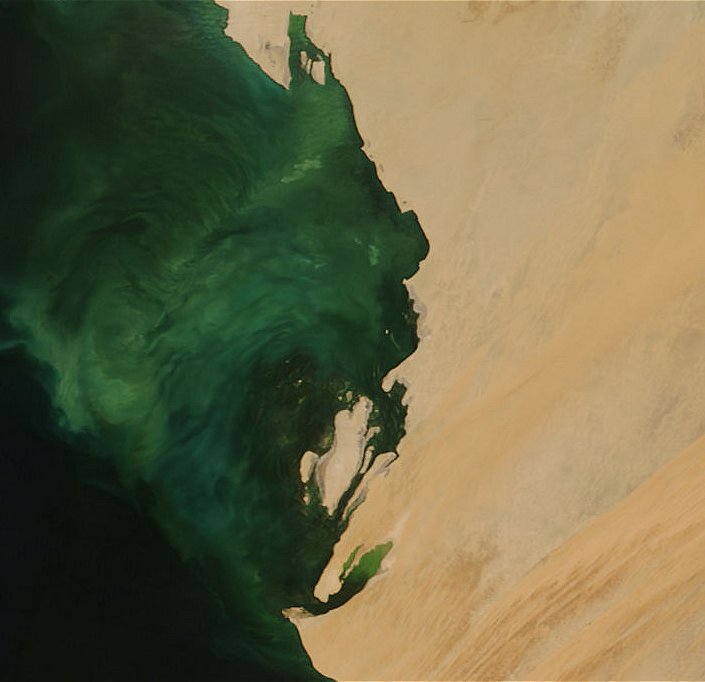
  In western Mauritania, the Sahara Desert extends all the way to the shore of the Atlantic Ocean. At this dramatic transition point lies the Banc d’Arguin National Park. The park encompasses shoreline dunes and small islands, as well coastal swamps, seagrass beds, mudflats, and shallow waters. The life in this park is concentrated in the ocean, where fish, dolphins, and sea turtles are among the inhabitants. Millions of migratory birds winter in the coastal waters; in fact, the park is home to the largest winter concentration of wading birds in the world. Thousands of aquatic birds, such as gray herons and white pelicans, breed there as well. The incredible biodiversity of the marine ecosystem is among the reasons Banc d’Arguin National Park is a UNESCO World Heritage Site. In western Mauritania, the Sahara Desert extends all the way to the shore of the Atlantic Ocean. At this dramatic transition point lies the Banc d’Arguin National Park. The park encompasses shoreline dunes and small islands, as well coastal swamps, seagrass beds, mudflats, and shallow waters. The life in this park is concentrated in the ocean, where fish, dolphins, and sea turtles are among the inhabitants. Millions of migratory birds winter in the coastal waters; in fact, the park is home to the largest winter concentration of wading birds in the world. Thousands of aquatic birds, such as gray herons and white pelicans, breed there as well. The incredible biodiversity of the marine ecosystem is among the reasons Banc d’Arguin National Park is a UNESCO World Heritage Site.
This image of western Mauritania shows the dramatic contrast between the bright sands of the Sahara Desert (right) and the turquoise color of the shallow water offshore. Most of the brightness of the water likely comes from sandy shoals ("banks") or mudflats that are submerged shallowly enough that their reflective sands can still be seen through the water. Tucked into a few bays and fringing the eastern side of Tidra Island are relict mangrove forests, small remaining fragments of a large estuary that thrived in the area in the Sahara’s distant, wetter past. Today, these relicts are the northernmost mangroves in the eastern Atlantic. The dry land portion of the park is a mixture of desert landscapes, from dark, rocky outcrops, to peach-colored rivers of sand dunes. |
| Source of material: NASA |
Further information: WikiPedia article on Banc d'Arguin National Park
Last Update: 2011-03-30

