| Earth from Space is a free eBook describing our planet from a satellite's perspective. Fore more information, please read the About pages. |

|

Home  Central America and Caribbean Central America and Caribbean  Nicaragua Nicaragua  Cosigüina Volcano Cosigüina Volcano |
|
| See also: Volcán Concepción | |


|
|
Cosigüina VolcanoPosition of center of photo (Lat/Long): [12.98/-87.57] |
|
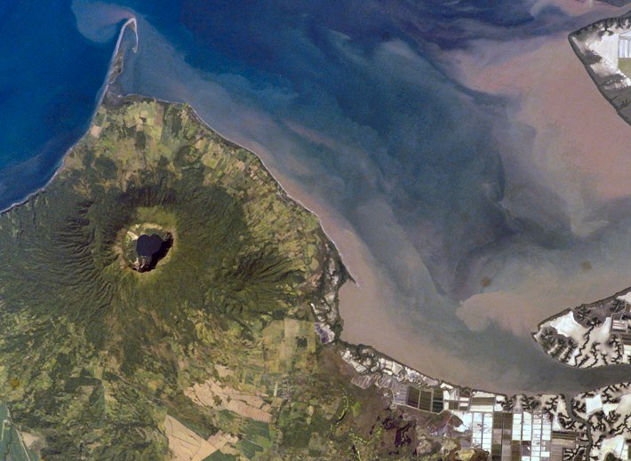
  Three Central American countries - El Salvador, Honduras, and Nicaragua - have coastline along the Gulf of Fonseca, which opens into the Pacific Ocean. The southern boundary of the Gulf is a peninsula formed by the Cosigüina Volcano. Cosigüina is a stratovolcano, which is a cone-shaped volcano formed by alternating layers of solidified lava and volcanic rocks produced by explosive eruptions. The summit crater is filled with a lake (Laguna Cosigüina). The volcano last erupted in 1859, but its most famous activity occurred in 1835, when it produced the largest historical eruption in Nicaragua. Ash from the 1835 eruption has been found in Mexico, Costa Rica, and Jamaica. Three Central American countries - El Salvador, Honduras, and Nicaragua - have coastline along the Gulf of Fonseca, which opens into the Pacific Ocean. The southern boundary of the Gulf is a peninsula formed by the Cosigüina Volcano. Cosigüina is a stratovolcano, which is a cone-shaped volcano formed by alternating layers of solidified lava and volcanic rocks produced by explosive eruptions. The summit crater is filled with a lake (Laguna Cosigüina). The volcano last erupted in 1859, but its most famous activity occurred in 1835, when it produced the largest historical eruption in Nicaragua. Ash from the 1835 eruption has been found in Mexico, Costa Rica, and Jamaica.
The volcano has been quiet since 1859, only an instant in terms of geological time. An earthquake swarm was measured near Cosigüina in 2002, indicating that tectonic forces are still active in the region although the volcano is somewhat isolated from the line of more recently active Central American volcanoes to the northwest and southeast. The only indicators of hydrothermal activity at the volcano are intermittently observed gas bubbles in Laguna Cosigüina and a hot spring along the eastern flank of the volcano. The fairly uniform vegetation cover (green) on the volcano’s sides also attest to a general lack of gas emissions or "hot spots" on the 872-meter-high cone. |
| Source of material: NASA |
Further information: WikiPedia article on Cosigüina Volcano
Last Update: 2011-03-30

