| Earth from Space is a free eBook describing our planet from a satellite's perspective. Fore more information, please read the About pages. |

|

Home  Europe Europe  Hungary Hungary  Danube Floods Vác Danube Floods Vác |
|
| See also: Lower Danube | |


|
|
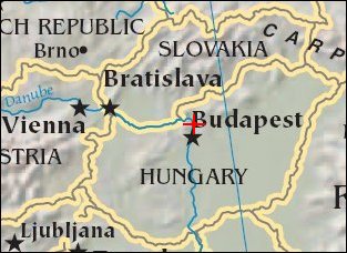
Danube Floods VácPosition of center of photo (Lat/Long): [47.79579/19.00073] |
|
  This image shows the devastating European flooding in August. The image was captured by astronauts using a digital still camera onboard the International Space Station (ISS). The photographs show flooding around the Danube Bend area just north of Budapest near the city of Vác, Hungary. The flood peaked in Budapest the day after this photo was made, on August 19, at about 8.5 meters (28 feet), exceeding the previous 1965 flood record. This image shows the waters inundating farmland in the flood plain. This image shows the devastating European flooding in August. The image was captured by astronauts using a digital still camera onboard the International Space Station (ISS). The photographs show flooding around the Danube Bend area just north of Budapest near the city of Vác, Hungary. The flood peaked in Budapest the day after this photo was made, on August 19, at about 8.5 meters (28 feet), exceeding the previous 1965 flood record. This image shows the waters inundating farmland in the flood plain.
|
| Source of material: NASA |
Further information: WikiPedia article on Danube Floods Vác
Last Update: 2011-03-30

