| Earth from Space is a free eBook describing our planet from a satellite's perspective. Fore more information, please read the About pages. |

|
Home  Asia Japan Fuji Asia Japan Fuji |
|
| See also: Japan - Honshu, Ground Photo of Mt. Fuji | |


|
  |
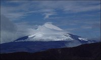
Mt. FujiPosition of center of photo (Lat/Long): [35.36260/138.73239] |
|
  Fuji, Japans tallest volcano (3,776 m) and a national symbol, is located about 110 km (70 miles) west-southwest of Tokyo in central Honshu, Japan. It is a highly recognizable target from space and last week International Space Station crew members peered down onto Fujis snow-capped cone. The summit crater is about 250 m deep, with a diameter of about 500 meters. Fuji last erupted in 1707 from Hoei crater, a vent on the mountains southeastern flank. Fuji, Japans tallest volcano (3,776 m) and a national symbol, is located about 110 km (70 miles) west-southwest of Tokyo in central Honshu, Japan. It is a highly recognizable target from space and last week International Space Station crew members peered down onto Fujis snow-capped cone. The summit crater is about 250 m deep, with a diameter of about 500 meters. Fuji last erupted in 1707 from Hoei crater, a vent on the mountains southeastern flank.
|
| Source of material: NASA |
Further information: WikiPedia article on Mt. Fuji
Last Update: 2011-03-30