| Earth from Space is a free eBook describing our planet from a satellite's perspective. Fore more information, please read the About pages. |

|

Home  Australia and Oceania Australia and Oceania  French Polynesia French Polynesia  Groupe Acteon Groupe Acteon |
|
| See also: Iles Gambier | |


|
|
Groupe ActeonPosition of center of photo (Lat/Long): [-21.38400/-136.51660] |
|
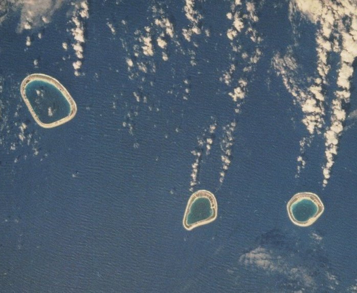
  Well to the south of the Tuamotu Archipelago (French Polynesia), not far from the southernmost island, Pitcairn, lies the Groupe Acteon, which is composed of four quite mature atolls: Tenararo, Vahanga, Tenarunga, and the Maturei-Vavao. Lying well to the south of the equator, they are more exposed to ocean swell from Southern Hemisphere winter storms than to the Equatorial Current that floods through Rangiroa, at the north end of the Tuamotus. Ocean swell was easily visible from the flight deck of the Challenger as the spacecraft crossed over the islands; especially evident were the wave-refraction patterns and the island wakes developed as the waves intersected and moved by the islands. Well to the south of the Tuamotu Archipelago (French Polynesia), not far from the southernmost island, Pitcairn, lies the Groupe Acteon, which is composed of four quite mature atolls: Tenararo, Vahanga, Tenarunga, and the Maturei-Vavao. Lying well to the south of the equator, they are more exposed to ocean swell from Southern Hemisphere winter storms than to the Equatorial Current that floods through Rangiroa, at the north end of the Tuamotus. Ocean swell was easily visible from the flight deck of the Challenger as the spacecraft crossed over the islands; especially evident were the wave-refraction patterns and the island wakes developed as the waves intersected and moved by the islands.
These four islands (only three of them visible) represent a mature form of atoll. There are no inlets into the lagoons. Flow of water in and out of the lagoons is in response to rising and falling tides, during which water slowly filters through the completely encircling reefs. At times, water from the open ocean floods into the lagoons from hurricane storm surges; the signs of this can be seen in the straight lines that have cut across the coconut groves. |
| Source of material: NASA |
Further information: WikiPedia article on Groupe Acteon
Last Update: 2011-03-30

