| Earth from Space is a free eBook describing our planet from a satellite's perspective. Fore more information, please read the About pages. |
|
Home  Middle East Yemen Jebel Al Tair Middle East Yemen Jebel Al Tair |
|
| See also: Ground Photo of Jebel Al Tair | |


|
  |
Jebel Al TairPosition of center of photo (Lat/Long): [15.54/41.83] |
|
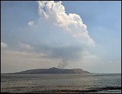
  On the evening of September 30, 2007, Jebel at Tair (Yemen) erupted, sending lava down its flanks and releasing a cloud of volcanic ash. On October 8, 2007, the Advanced Spaceborne Thermal Emission and Reflection Radiometer (ASTER) on NASAs Terra satellite acquired this image. A glowing hot spot and a faint volcanic plume suggest that, although the volcano had quieted since September 30, its activity had not completely stopped. On the evening of September 30, 2007, Jebel at Tair (Yemen) erupted, sending lava down its flanks and releasing a cloud of volcanic ash. On October 8, 2007, the Advanced Spaceborne Thermal Emission and Reflection Radiometer (ASTER) on NASAs Terra satellite acquired this image. A glowing hot spot and a faint volcanic plume suggest that, although the volcano had quieted since September 30, its activity had not completely stopped.
ASTER measures not only light visible to human eyes, but also infrared light, enabling the sensor to detect thermal anomalies caused by substantial temperature differences. The bright red spot at the summit is such an anomaly, and it suggests hot lava associated with ongoing volcanic activity. Immediately to the north of the summit is a small faint red streak, another thermal anomaly that appears to flow down the volcanos slope. At the same time, a nearly transparent plume emanates from the summit up toward a cloud. Water content of the volcanic plume could be responsible for this cloud, although clouds do routinely form over summits, even when the volcanoes are not active.
Jebel at Tair is a stratovolcano - a steep-sloped cone composed of alternating layers of ash, lava, and rocks produced by earlier eruptions. The latest eruption is a continuation of activity on this island, where explosive eruptions were recorded in the eighteenth and nineteenth centuries. Jebel at Tair is known by multiple names and spellings. It has alternately been referred to as Jabal al-Tair, Jabal al-Tayr, Tair Island, Al-Tair Island, Djebel Teyr, Saiban, and Jibbel Tir. |
| Source of material: NASA |
Further information: WikiPedia article on Jebel Al Tair
Last Update: 2011-03-30