| Earth from Space is a free eBook describing our planet from a satellite's perspective. Fore more information, please read the About pages. |

|

Home  Europe Europe  Jersey Jersey  Isle of Jersey Isle of Jersey |
|


|
|
Isle of JerseyPosition of center of photo (Lat/Long): [49.21589/-2.13180] |
|
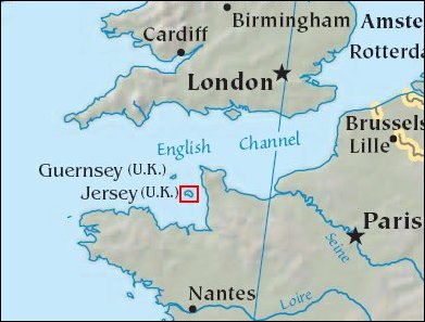
  The Isle of Jersey (officially called the Bailiwick of Jersey) is the largest Channel Island, positioned in the Bay of Mont St Michel off the north-west coast of France. The island has a population of about 90,000, and covers about 90 square kilometers. The economy is based largely on international financial services, agriculture, and tourism. Called Caesaria in Roman times, Jersey became part of the Duchy of Normandy in 912. When William the Conqueror invaded and took the throne of England in 1066, the fortunes of Jersey then became linked to those in England, although the island manages its internal affairs through its own parliament, the States of Jersey. This image was acquired September 23, 2000, covers an area of 16.5 x 21 km, and is located at 49.2 degrees north latitude and 2.1 degrees west longitude. The Isle of Jersey (officially called the Bailiwick of Jersey) is the largest Channel Island, positioned in the Bay of Mont St Michel off the north-west coast of France. The island has a population of about 90,000, and covers about 90 square kilometers. The economy is based largely on international financial services, agriculture, and tourism. Called Caesaria in Roman times, Jersey became part of the Duchy of Normandy in 912. When William the Conqueror invaded and took the throne of England in 1066, the fortunes of Jersey then became linked to those in England, although the island manages its internal affairs through its own parliament, the States of Jersey. This image was acquired September 23, 2000, covers an area of 16.5 x 21 km, and is located at 49.2 degrees north latitude and 2.1 degrees west longitude.
|
| Source of material: NASA Foto: ASTER Science Team |
Further information: WikiPedia article on Isle of Jersey
Last Update: 2011-03-30

