| Earth from Space is a free eBook describing our planet from a satellite's perspective. Fore more information, please read the About pages. |

|

Home  Middle East Middle East  Oman Oman  Northern Oman Northern Oman |
|
| See also: Salalah, Sultanate of Oman, Qeshm Island | |


|
|
Northern OmanPosition of center of photo (Lat/Long): [25/57] |
|
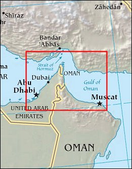
  Much of Omanís landscape is low-lying, hot, and dry. Its extensive sand seas stretch westward into the neighboring countries of Saudi Arabia and United Arab Emirates. Northern Oman, however, contains rugged mountains and some of the highest elevations in eastern Arabia. In this region, relatively cool, moist weather has given rise to a richly vegetated landscape. In northernmost Oman, north of the United Arab Emirates, steep-sloped mountains rise from ocean waters.
In contrast to the orange-tinted sands in the west, the mountains of northern Oman range in color from pale beige to deep green-brown. The regionís mountain peaks consist primarily of Cretaceous limestone - originally formed from sediments laid down deep underwater at the time of the last dinosaurs. Igneous rocks (formed from magma) and metamorphic rocks (changed by intense heat and/or pressure) also occur in these mountains. Northeastern Omanís mountains form an arc that roughly mimics the shape of the coastline. Jabal Shams
The northernmost part of Oman is separated from the rest of the country by the United Arab Emirates. This northernmost part of Oman occupies the Musandam Peninsula, which offers tourists no sandy beaches. Instead, mariners must carefully negotiate cliffs and steep slopes that shoot out of the water to elevations of roughly 900 to 1,200 meters. |
| Source of material: NASA |
Further information: WikiPedia article on Northern Oman
Last Update: 2011-03-30


