| Earth from Space is a free eBook describing our planet from a satellite's perspective. Fore more information, please read the About pages. |

|

Home  Africa Africa  Egypt Egypt  Suez Canal Suez Canal |
|
| See also: Nile Delta, Port of Suez | |


|
|
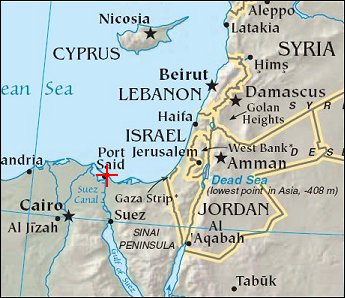
Suez CanalPosition of center of photo (Lat/Long): [31.23530/32.33421] |
|
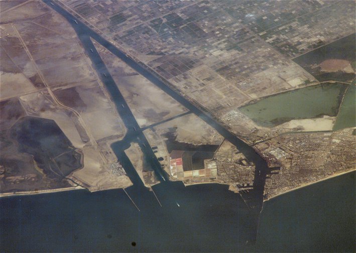
  Ship traffic on the Suez Canal, Egypt, is featured in this image photographed by an Expedition 13 crew member on the International Space Station. This oblique photograph captures a northbound convoy of cargo ships entering the Mediterranean Sea from the Suez Canal in Egypt (leftmost canal branch at image center). Oblique images are taken at an angle other than vertical, or nadir - looking down a line connecting the station to the point on the Earth's surface directly below it - and this provides a sense of perspective. In this case, the station was located above the eastern coast of Cyprus and the crew member was looking at Egypt to the southwest. Regions of reduced clarity in the image are caused by thin variable cloud cover. The Suez Canal connects Port Said on the Mediterranean Sea with the port of Suez on the Red Sea, and provides an essentially direct route for transport of goods between Europe and Asia. The Canal is 163 kilometers long and 300 meters wide at its narrowest point - sufficiently wide for ships as large as aircraft carriers to traverse it. Transit time from end to end is 14 hours on average. Ship traffic on the Suez Canal, Egypt, is featured in this image photographed by an Expedition 13 crew member on the International Space Station. This oblique photograph captures a northbound convoy of cargo ships entering the Mediterranean Sea from the Suez Canal in Egypt (leftmost canal branch at image center). Oblique images are taken at an angle other than vertical, or nadir - looking down a line connecting the station to the point on the Earth's surface directly below it - and this provides a sense of perspective. In this case, the station was located above the eastern coast of Cyprus and the crew member was looking at Egypt to the southwest. Regions of reduced clarity in the image are caused by thin variable cloud cover. The Suez Canal connects Port Said on the Mediterranean Sea with the port of Suez on the Red Sea, and provides an essentially direct route for transport of goods between Europe and Asia. The Canal is 163 kilometers long and 300 meters wide at its narrowest point - sufficiently wide for ships as large as aircraft carriers to traverse it. Transit time from end to end is 14 hours on average.
|
| Source of material: NASA |
Further information: WikiPedia article on Suez Canal
Last Update: 2011-03-30

