| Earth from Space is a free eBook describing our planet from a satellite's perspective. Fore more information, please read the About pages. |

|

Home  Africa Africa  Egypt Egypt  Alexandria Alexandria |
|
| See also: Nile Delta | |


|
|
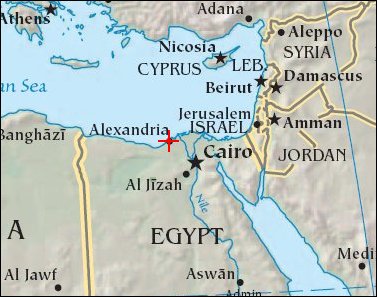
AlexandriaPosition of center of photo (Lat/Long): [31.19304/29.90577] |
|
  Alexandria (Al Iskandariya) (Egypt) occupies a T-shaped peninsula and strip of land separating the Mediterranean from Lake Mariout. Originally the town was built upon a mole (stone breakwater) called Heptastadium, which joined the island of Pharos to the mainland. Since then sedimentary deposits have widened the mole. Since 1905, when the 370,000 Alexandrians lived in an area of about 4 sq km between the two harbors, the city (population 4 million; see referenced website, below) has grown beyond its medieval walls and now occupies an area of about 300 sq km.
Founded by Alexander the Great in 331 BC on the Mediterranean coast of Egypt, Alexandria became a center of trade and learning in the ancient world. Alexander built the causeway between the Eastern and Western Harbors, joining Pharos Island to the mainland. Alexandria’s cultural status was symbolized by the lighthouse on Pharos, one of the "Seven Wonders of the World". The causeway is still known as the old part of the modern city. Since the year 2000, underwater archeologists have located the sunken palace, ceremonial buildings and port facilities of ancient Alexandria, located along most of the curved southern shoreline of the Eastern Harbor. The Eastern Harbor was the main port in the Middle Ages. This detailed image taken by Space Station crew members using an 800-mm lens provides a view of the modern port facilities in the Western Harbor, where wharves and many moored ships can be detected. |
| Source of material: NASA |
Further information: WikiPedia article on Alexandria
Last Update: 2011-03-30

