| Earth from Space is a free eBook describing our planet from a satellite's perspective. Fore more information, please read the About pages. |

|

Home  Europe Europe  France France  Bassas da India Bassas da India |
|


|
|
Bassas da IndiaPosition of center of photo (Lat/Long): [-21.4825/39.6719] |
|
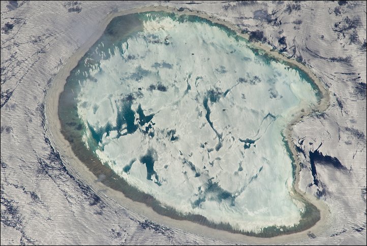
  The vantage point on the International Space Station provides astronauts with many dramatic views of Earth. Occasionally those views become spectacular. This photograph of the Bassas da India, an uninhabited atoll in the Indian Ocean, has an almost surreal quality due to varying degrees of sunglint.
Sunglint is caused by light reflecting off a water surface directly back towards the observer. Variations in the roughness of the water surface - the presence or absence of waves due to wind and currents - will cause differences in the intensity of the sunglint. The presence of other materials, such as oils or surfactants, can also change the properties of the water surface. In this image, the presence of currents is highlighted as darker patches or streaks (image left and upper right). In contrast, shallow water in the lagoon presents a more uniform, mirror-like appearance, suggesting that there are no subsurface currents. Wave crests visible around the atoll are likely the result of both surface winds and subsurface currents. Located between the Mozambique coast of Africa and the island of Madagascar, Bassas da India is part of the French Southern and Antarctic Lands. It is uninhabited because it is completely submerged at high tide; there is no vegetation on the atoll for the same reason. The atoll is approximately 10 kilometers in diameter, and covers an area (including the lagoon) of approximately 80 square kilometers. |
| Source of material: NASA |
Further information: WikiPedia article on Bassas da India
Last Update: 2011-05-13

