| Earth from Space is a free eBook describing our planet from a satellite's perspective. Fore more information, please read the About pages. |

|
Home  Africa Cape Verde Fogo Africa Cape Verde Fogo |
|
| See also: Cape Verde, Ilha do Sal | |


|
  |
FogoPosition of center of photo (Lat/Long): [14.95/-24.339] |
|
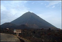
  Fogo - fire - is an apt name for this imposing volcanic island. One of the Cabo Verde Islands located roughly 640 kilometers off the westernmost tip of Africa, Fogo received its name from Portuguese colonists around 1500 AD. The volcano was almost continuously active from that time until about 1760, said the Smithsonian Global Volcanism Program. The volcanos most distinctive feature, its nine-kilometer wide caldera, Cha Caldera, is shown in this image
  . The crater wall in the west towers one kilometer above the crater floor. The eastern half of the crater wall is gone, erased in a massive collapse deep in its ancient history. . The crater wall in the west towers one kilometer above the crater floor. The eastern half of the crater wall is gone, erased in a massive collapse deep in its ancient history.
Dark trails of hardened lava from the volcanos most recent eruptions stream out of the crater east into the Atlantic Ocean. The volcano last erupted in 1995. The sepia stream of lava from that eruption is pooled near the crater rim west of Pico. Remarkably, the crater is inhabited. A straight road cuts between the crater wall and Pico, ending near the vent that erupted in 1995. Bright white dots on the north side of the crater are houses. Residents of the Cha Caldera evacuated during the eruption.
|
| Source of material: NASA |
Further information: WikiPedia article on Fogo
Last Update: 2011-03-30