| Earth from Space is a free eBook describing our planet from a satellite's perspective. Fore more information, please read the About pages. |
|
Home  Africa Cape Verde Sal Africa Cape Verde Sal |
|
| See also: Cape Verde, Fogo | |


|
  |
Ilha do SalPosition of center of photo (Lat/Long): [16.7/-22.95] |
|
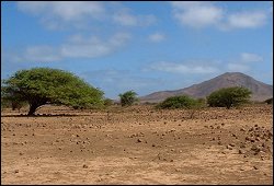
  The island of Sal (Ilha do Sal) is an island in the Cabo Verde archipelago. The island is about 30 km long and 12 km wide (area of 216 km2. It belongs to the Barlavento (northern) group of islands and is one of the three sandy eastern islands (Sal, Boa Vista and Maio). Sal has beautiful white beaches and is fairly flat, with the highest elevation at 406 m (Monte Grande).
Sal was discovered on December 3, 1460 and named Llana ("plain" in Portuguese) until salt deposits were found. Sal is the oldest island in Cape Verde, formed 50 million years ago during the eruption of a volcano which is now inactive.
The Amilcar Cabral International Airport, was used as a refuelling base by South African Airways on its Johannesburg to London routes. Later, flights to and from New York and Atlanta also refuelled there, and the island was a crew-change station.
|
| Source of material: NASA |

Further information: WikiPedia article on Ilha do Sal
Last Update: 2011-03-30