| Earth from Space is a free eBook describing our planet from a satellite's perspective. Fore more information, please read the About pages. |

|

Home  South America South America  Chile Chile  Cape Horn Cape Horn |
|
| See also: Tierra del Fuego, Cape Horn - Detailed Map | |


|
|
Cape HornPosition of center of photo (Lat/Long): [-55.84504/-67.51664] |
|
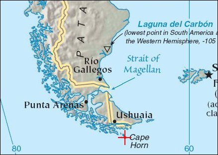
  Cape Horn is the southernmoast island at the tip of South America. The archipelago, which Cape Horn is part of is called Tierra del Fuego (Chile). At times before the Panama Canal was completed ships had to go around Cape Horn in order to cross from the Atlantic to the Pacific. This area is was one of the most dreaded for its strong winds and icebergs drifting up from Antarctica. A more detailed map of Cape Horn is also available from "Earth From Space". Cape Horn is the southernmoast island at the tip of South America. The archipelago, which Cape Horn is part of is called Tierra del Fuego (Chile). At times before the Panama Canal was completed ships had to go around Cape Horn in order to cross from the Atlantic to the Pacific. This area is was one of the most dreaded for its strong winds and icebergs drifting up from Antarctica. A more detailed map of Cape Horn is also available from "Earth From Space".
The satellite image shows some of the islands around Cape Horn, including the Wollaston Islands (top right) and the Hermite Islands (center). Cape Horn sits on one of the Hermite Islands, Isla Hornos. Precipitation is abundant in the area, and the islands are lush with green vegetation except at high elevations, where bare rock appears to be exposed. Small lakes (easy to confuse with shadows) are scattered across most of the islands. A veil of thin clouds hangs over much of the scene, and bright white snow stands out on the east-facing summits of the mountains on the Wollaston Islands. Along some of the coastlines, white lines of breaking surf swirl in the water. |
| Source of material: NASA |
Further information: WikiPedia article on Cape Horn
Last Update: 2011-08-02

