| Earth from Space is a free eBook describing our planet from a satellite's perspective. Fore more information, please read the About pages. |

|

Home  Europe Europe  Spain Spain  Strait of Gibraltar Strait of Gibraltar |
|
| See also: Europe meets Africa, Gibraltar Bay, Ceuta | |


|
|
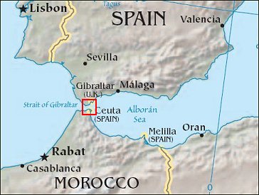
Strait of GibraltarPosition of center of photo (Lat/Long): [35.97528/-5.52266] |
|
  Surf’s up! This image is a mosaic of two photographs taken by astronauts aboard the International Space Station viewing large internal waves in the Strait of Gibraltar. These subsurface internal waves occur at depths of about 100 m, but appear in the sunglint as giant swells flowing eastward into the Mediterranean Sea. Surf’s up! This image is a mosaic of two photographs taken by astronauts aboard the International Space Station viewing large internal waves in the Strait of Gibraltar. These subsurface internal waves occur at depths of about 100 m, but appear in the sunglint as giant swells flowing eastward into the Mediterranean Sea.
The narrow Strait of Gibraltar is the gatekeeper for water exchange between the Atlantic Ocean and Mediterranean Sea. A top layer of warm, relatively fresh water from the Atlantic Ocean flows eastward into the Mediterranean Sea. In return, a lower, colder, saltier layer of water flows westward into the North Atlantic ocean. A density boundary separates the layers at about 100 m depth.
In this image, the tidal bore creates internal waves (top arrow) that propagate eastward and expand outward into the Mediterranean in a big arc (near bottom). Other features can be traced in the sun’s reflections. Linear and V-shaped patterns (bottom arrow) are wakes of ships, providing evidence for the heavy ship traffic through the narrow waters between Spain and Morocco. Water features in the sunglint pattern appear to the astronaut to be extremely transient, visible only briefly (a few seconds) as the spacecraft passes rapidly overhead. Photographs from space of the ocean sunglint pattern are a tool for studying physical oceanographic and atmospheric processes and other phenomena that affect surface roughness. |
| Source of material: NASA |
Further information: WikiPedia article on Strait of Gibraltar
Last Update: 2011-03-30


