| Earth from Space is a free eBook describing our planet from a satellite's perspective. Fore more information, please read the About pages. |

|

Home  North America North America  USA USA  Hawaii Hawaii  Hawaii - Oahu Hawaii - Oahu |
|
| See also: Hawaii, Honolulu Airport, Hawaiian Islands | |


|
|
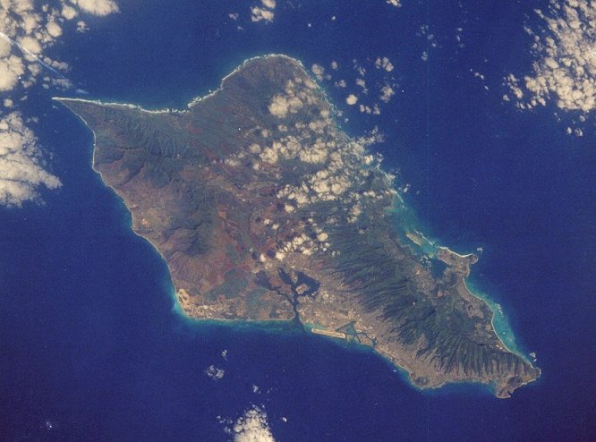
Hawaii - OahuPosition of center of photo (Lat/Long): [21.43933/-157.96317] |
|
  Oahu, Pearl Harbor, Honolulu, Diamond Head, the sheer Pali cliffs, and the famous winter surf on the north shore of the island all were easily visible to the fourth crew aboard the Challenger. Oahu is the third island from the north end of the Hawaiian chain and is representative of that part of Hawaii (United States) where volcanic activities have lorig since become dormant. A fringing coral reef lies against the shores of Oahu and is best developed on the windward side at Kaneohe Bay. Oahu, Pearl Harbor, Honolulu, Diamond Head, the sheer Pali cliffs, and the famous winter surf on the north shore of the island all were easily visible to the fourth crew aboard the Challenger. Oahu is the third island from the north end of the Hawaiian chain and is representative of that part of Hawaii (United States) where volcanic activities have lorig since become dormant. A fringing coral reef lies against the shores of Oahu and is best developed on the windward side at Kaneohe Bay. Geologists believe that the crust of the sea floor on which the Hawaiian chain lies has been moving toward the northwest at a rate of 10 centimeters a year for some 200 million years. As this movement takes place, the sea floor passes over a "hot spot" in the earth's mantle below the crust, producing volcanic eruptions sufficiently large to create an island mass over long periods of time. The hot spot apparently has remained fixed, so that as the crust moves to the northwest, new islands are formed in sequence. Thus, the oldest islands are to the north, ending with the submerged sea mounts northwest of Kure Atoll, the youngest at the south end of the chain. Recent bathymetric surveys southeast of Hawaii indicate formation of a new volcanic island on the ocean floor. |
| Source of material: NASA |
Further information: WikiPedia article on Hawaii - Oahu
Last Update: 2011-03-30

