| Earth from Space is a free eBook describing our planet from a satellite's perspective. Fore more information, please read the About pages. |

|

Home  South America South America  Argentina Argentina  Moreno Glacier Moreno Glacier |
|
| See also: Tierra del Fuego | |


|
|
Moreno GlacierPosition of center of photo (Lat/Long): [-50.43528/-72.89841] |
|
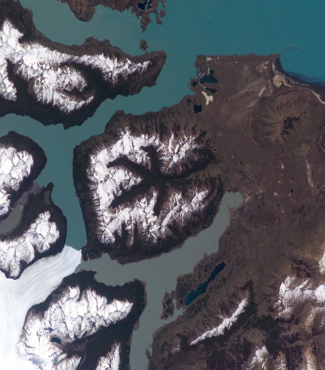
  Perito Moreno (or Moreno Glacier) is located in the icefields of southern Patagonia (Argentina) and is the centerpiece of the Parque Nacional Los Glaciares. The glacier is also noteworthy as a tourist attraction, due to periodic formation of an ice dam between the main portion of Lago (Lake) Argentino to the northeast and a southern extension of the lake (Brazo Rico). Meltwater runoff from the surrounding mountains fills Brazo Rico to a higher elevation than nearby Lago Argentino and exerts hydrostatic pressure on the ice dam. This pressure leads to formation of drainage tunnels and fractures in the ice dam, which eventually fails. Earlier this year (March 2004) the ice dam collapsed in a spectacular show. Perito Moreno (or Moreno Glacier) is located in the icefields of southern Patagonia (Argentina) and is the centerpiece of the Parque Nacional Los Glaciares. The glacier is also noteworthy as a tourist attraction, due to periodic formation of an ice dam between the main portion of Lago (Lake) Argentino to the northeast and a southern extension of the lake (Brazo Rico). Meltwater runoff from the surrounding mountains fills Brazo Rico to a higher elevation than nearby Lago Argentino and exerts hydrostatic pressure on the ice dam. This pressure leads to formation of drainage tunnels and fractures in the ice dam, which eventually fails. Earlier this year (March 2004) the ice dam collapsed in a spectacular show.
A new ice dam across the Brazo Rico arm of Lago Argentino is visible in this astronaut photograph. The past extent of glaciation in the region is marked by several valleys formerly filled by flowing ice. A particularly striking example of this landscape feature is in the center of the image, where five glacial valleys converge to a central star-shaped outflow valley. Widespread recession of the glaciers in southern Patagonia has occurred over the last 30 years possibly due to warming of the regional climate. Contrary to this trend, Perito Moreno seems to be maintaining equilibrium between ice formation in the mountains and ice loss due to melting and calving into Lago Argentino. |
| Source of material: NASA |
Further information: WikiPedia article on Moreno Glacier
Last Update: 2011-03-30

