| Earth from Space is a free eBook describing our planet from a satellite's perspective. Fore more information, please read the About pages. |

|

Home  Europe Europe  Netherlands Netherlands  Netherlands Dikes Netherlands Dikes |
|


|
|
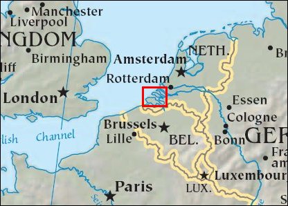
Netherlands DikesPosition of center of photo (Lat/Long): [51.70989/3.97015] |
|
  On the night of January 31, 1953, a combination of high spring tides and a strong windstorm caused the North Sea to surge onto coastal areas of the United Kingdom and the Netherlands, causing a major natural disaster. Thousands of lives were lost both on land and at sea. After the tragic event, the Netherlands undertook a major engineering project known as "Delta Works". The project involved the fortification of seawalls, expansion of canals, and construction of dikes, dams, and locks. On the night of January 31, 1953, a combination of high spring tides and a strong windstorm caused the North Sea to surge onto coastal areas of the United Kingdom and the Netherlands, causing a major natural disaster. Thousands of lives were lost both on land and at sea. After the tragic event, the Netherlands undertook a major engineering project known as "Delta Works". The project involved the fortification of seawalls, expansion of canals, and construction of dikes, dams, and locks.
The southwestern coastline of the Netherlands, shown here, was especially vulnerable because it was composed of a series of islands crisscrossed with river outlets and estuaries. This image shows the results of the Delta Works project on the islands of the Netherlands southernmost coastal province, known as Zealand, which translates to "Sea Land". Islands, once unconnected, are today linked by dikes and seawalls, and rivers and estuaries once open directly to the North Sea are enclosed as lakes. The patchwork of green, cream, and lavender colors on the islands shows the prevalence of agriculture in the province and fields in various stages of growth or harvest. The islands are cut through by the blue ribbons of canal, such as the Scheldt-Rhine Canal that flows into the image at lower right, cuts through Tholen Island and ends in the Krammer Strait. In the Eastern Scheldt Estuary, several light purple sandbars sit below the surface of the water. The high-resolution image shows ships in some of the canals and in the North Sea. |
| Source of material: NASA |
Further information: WikiPedia article on Netherlands Dikes
Last Update: 2011-03-30

