| Earth from Space is a free eBook describing our planet from a satellite's perspective. Fore more information, please read the About pages. |

|
Home  Africa Namibia Tsauchab River Africa Namibia Tsauchab River |
|
| See also: Tsauchab, Kuiseb River | |


|
  |
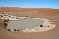
Tsauchab River and Sossus Vlei LakebedPosition of center of photo (Lat/Long): [-24.7/15.333] |
|
  This image shows the lower 45 kilometers of the Tsauchab River, a famous landmark for Namibians, tourists, and for orbiting astronauts. The Tsauchab River bed is seen jutting into the sea of red dunes near Namibias hyper-arid coast. The riverbed ends in a series of light-colored, silty mud holes on the dry lake floor, known locally as Sossus Vlei ("small lake"). This image shows the lower 45 kilometers of the Tsauchab River, a famous landmark for Namibians, tourists, and for orbiting astronauts. The Tsauchab River bed is seen jutting into the sea of red dunes near Namibias hyper-arid coast. The riverbed ends in a series of light-colored, silty mud holes on the dry lake floor, known locally as Sossus Vlei ("small lake").
Because of the present arid climate, few people have ever seen the Tsauchab River with flowing water or a lake in Sossus Vlei. In times past, however, the Tsauchab appears to have reached the Atlantic coast, another 55 kilometers farther west. Like several other rivers of the coastal Namib Desert, the Tsauchab brings sediment down from the hinterland to the coastal lowland. This sediment is then blown from the river beds, and over probably tens of millions of years, has accumulated as the red dunes of the impressive Namib Sand Sea.
These northeasterly winds are likely responsible for the regular dune arms that point into the valley from both sides. These large dunes facing the river valley are promoted as the highest dunes in the world. Although continuous dune slopes allow hikers to ascend to altitudes more than 300 meters above the river bottom, not all of that elevation gain has to be walked; the main base of the dunes lies on a terrace 180 meters above the river. |
| Source of material: NASA |
Further information: WikiPedia article on Tsauchab River and Sossus Vlei Lakebed
Last Update: 2011-03-30