| Earth from Space is a free eBook describing our planet from a satellite's perspective. Fore more information, please read the About pages. |

|

Home  Africa Africa  Tunisia Tunisia  Tunisia Tunisia |
|
| See also: Djerba | |


|
|
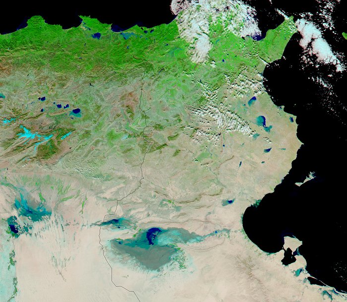
Floods in TunisiaPosition of center of photo (Lat/Long): [35.52036/9.28089] |
|
  In early January 2003 heavy rains in Tunisia have led to floods that have displaced over 3,000 people. The floods can be seen in this false-color image acquired on January 19, 2003, by the Moderate Resolution Imaging Spectroradiometer (MODIS) aboard NASA's Terra spacecraft. The most devastating floods occurred in the northern and central parts of Tunisia. Most of the houses affected were built of soil and provided ample protection from the normally hot, arid conditions. In the unusually heavy rains and floods of the past few weeks, however, these dwellings simply crumbled. Cattle and food stocks have also been lost. In early January 2003 heavy rains in Tunisia have led to floods that have displaced over 3,000 people. The floods can be seen in this false-color image acquired on January 19, 2003, by the Moderate Resolution Imaging Spectroradiometer (MODIS) aboard NASA's Terra spacecraft. The most devastating floods occurred in the northern and central parts of Tunisia. Most of the houses affected were built of soil and provided ample protection from the normally hot, arid conditions. In the unusually heavy rains and floods of the past few weeks, however, these dwellings simply crumbled. Cattle and food stocks have also been lost.
In the lower right corner of the satellite photo you can see the island of Djerba which is one of the major touristic attractions of Tunisia. |
| Source of material: NASA |
Further information: WikiPedia article on Floods in Tunisia
Last Update: 2011-04-04


